Do’s and Don’ts pertaining to Cyclone 
|
| |
| • |
Gujarat has two storm seasons: May and June during the onset of the monsoon and October and November during the retreat of southwestern monsoon. |
| • |
The estimated mean taluka basic wind speed (in m/sec) zonation for a 25-year return period is presented below which shows a maximum wind speed class between 34 to 39 m/sec along the western sea board of Saurashtra, which is exposed to the highest intensity of cyclonic and storm impact. |
| |
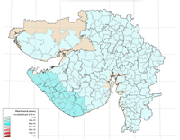 |
| • |
The estimated mean taluka basic wind speed (in m/sec) zonation for a 50-year return period is presented in below. This shows a maximum wind speed class of 45 to 47 class m/sec along the Saurashtra coast,specifically in Porbandar, Jamnagar and Junagadh districts, which are exposed to the highest intensity of cyclonic and storm impact. |
| |
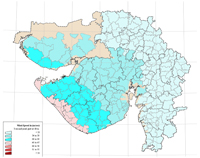 |
| • |
The estimated mean taluka basic wind speed (in m/sec) zonation for a 100-year return period is presented in the figure below. This zonation would typically be used for a design of engineered and critical buildings and infrastructure with a mean design service life of 100 years. This map shows a maximum wind speed class of <55 m/ sec along the Saurashtra coast, specifically in Porbandar, Jamnagar and Junagadh districts, which are exposed to the highest intensity of cyclonic and storm impact. |
| |
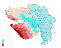 |
| • |
The estimated mean Taluka basic wind speed (in m/sec) zonation for a 200-year return period is presented which shows the bulk of Saurashtra and the western coastal Talukas of Kachchh fall into the <55 m/sec class in this zonation. A narrow band of 51 to 55 m/sec and a more or less contiguous band of 48 to 50 m/sec and 45 to 47 m/sec cuts a swathe across Kachchh, Saurashtra and coastal South Gujarat. |
| |
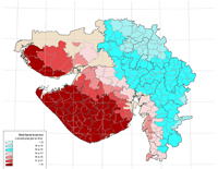 |
| |
| |
Important Links For Furthure Information |
| |
|
| |
India Meteorological Department, Government of India |
| |
Meteorological Centre, Ahmedabad |
| |
CSIR-National Institute of Oceanography, Goa |
| |
National Disaster Management Authority, GoI |
| |
GSDMA Leaflets In Gujarati |
|